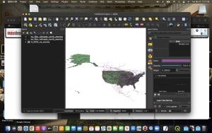
For this week’s blog we will continue in the exploration of spatial softwares for digital history, particularly QGIS and its many useful features. As usual, I will begin this post by identifying the troubleshoots and other difficulties that I came across in getting the software properly onto my computer right down to uploading the maps for Dr. Gibb’s confusing tutorials.
For starters, I had a painstaking moment at my computer desk waiting for my laptop to upoload the QGIS program only to find that the file could not be properly read therefore prohibiting the program to install. I had to download the long term and stable download file for QGIS to properly load onto my computer which I was then greeted with a blank page without any visualization. Noted, I knew that this was expected given what was mentioned in class but I found the interface itself to be rather cumbersome in navigating. There was no labeling on where to go and worse at one point in blindly clicking away at tabs I had deleted the layer management tab which forced me to learn to use their Mac controls to create new vector layers,etc. My second largest gripe in learning to use QGIS was the tutorial links provided often were non-existent or they diverged from the simplicity that they were supposed to be in downloading them. For instance when downloading one of the datasets for the first tutorial, the Excel CSV sheet was a blank tab with all the information that I had to copy and paste into a new spreadsheet I had to make, then properly export into a CSV when the tutorial said it would do all that for me.
Enough about my rambles, lets get into the real meat and potatoes in using QGIS for this week. Dr. Gibb’s first tutorial was very straightforward although I do admit that his way of walking through the interface lacked more screenshots to help me comprehend where certain things were. It was a fairly simply tutorial that did a good job in familiarizing the basic functions of the program which was a great segway into the next tutorial that explored plotting county densities.
https://web.archive.org/web/20210510023022/http://fredgibbs.net/tutorials/qgis/making-a-map-with-qgis.html
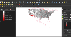
This is where many of the personal gripes with QGIS persisted as I struggled in getting the map to be able to read the data I tried joining with it to then create a population density visualization. After about half an hour of frustration over my desktop I managed to correct the error that I had made which was mentioned in Gibb’s tutorial but was not explicitly a screenshot which could have saved me so much time.
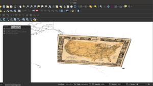
The last tutorial was supposed to bethe most fun to work as taught how to import a historical railroad map onto the visualization that we had worked on up to this point. Now I may have mentioned it before in class, but I love railroad history in the U.S so to see a map of the different railroad companies was fascinating to look at before pressing forward with the last tutorial of the series. Here again I ran into slight technical difficulties where I cannot express the gratitude I have for both my classmates and Professor in trying to help me resolve this issue. Here I struggled in trying to overlap the historical map onto the QGIS map that I had made in the previous tutorials. My issue came down in the geo-referencer where I would plot my points and click on the transformations but without clicking the “load to GIS when done.” So you can bet your top dollar that I felt like Indiana Jones holding the proper Holy Grail in the Last Crusades when I finally saw the historical map load all warped onto my GIS map.
Overall, I would say that learning to use QGIS was the most frustrating interface yet to use but as always the experience was worth the trouble and it taught me that one of the best means of achieving the end result is not blatant persistence but a calm and measured mindset that it aware of such technical difficulties.